


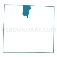
Voting District 0105, Denton County, Texas
About
Outline

Summary
| Unique Area Identifier | 672582 |
| Name | Voting District 0105 |
| County | Denton County |
| State | Texas |
| Area (square miles) | 26.84 |
| Land Area (square miles) | 22.91 |
| Water Area (square miles) | 3.93 |
| % of Land Area | 85.34 |
| % of Water Area | 14.66 |
| Latitude of the Internal Point | 33.38243740 |
| Longtitude of the Internal Point | -97.14472250 |
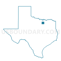
Maps

Graphs
Select a template below for downloading or customizing gragh for Voting District 0105, Denton County, Texas


Neighbors
Neighoring Voting District (by Name) Neighboring Voting District on the Map
- Voting District 0011, Cooke County, TX
- Voting District 0100, Denton County, TX
- Voting District 0116, Denton County, TX
- Voting District 0121, Denton County, TX
- Voting District 0128, Denton County, TX
- Voting District 0133, Denton County, TX
Top 10 Neighboring County Subdivision (by Population) Neighboring County Subdivision on the Map
- Denton CCD, Denton County, TX (96,510)
- Pilot Point-Aubrey CCD, Denton County, TX (77,826)
- Sanger CCD, Denton County, TX (19,726)
- Gainesville Southeast CCD, Cooke County, TX (7,112)
- Valley View CCD, Cooke County, TX (4,774)
Top 10 Neighboring Place (by Population) Neighboring Place on the Map
Top 10 Neighboring Unified School District (by Population) Neighboring Unified School District on the Map
- Denton Independent School District, TX (157,936)
- Sanger Independent School District, TX (12,886)
- Pilot Point Independent School District, TX (8,041)
- Valley View Independent School District, TX (3,144)
Top 10 Neighboring State Legislative District Lower Chamber (by Population) Neighboring State Legislative District Lower Chamber on the Map
- State House District 64, TX (219,345)
- State House District 63, TX (218,386)
- State House District 68, TX (135,942)
Top 10 Neighboring State Legislative District Upper Chamber (by Population) Neighboring State Legislative District Upper Chamber on the Map
Top 10 Neighboring 111th Congressional District (by Population) Neighboring 111th Congressional District on the Map
Top 10 Neighboring Census Tract (by Population) Neighboring Census Tract on the Map
- Census Tract 201.03, Denton County, TX (10,076)
- Census Tract 202.02, Denton County, TX (9,228)
- Census Tract 204.01, Denton County, TX (6,622)
- Census Tract 7, Cooke County, TX (6,531)
- Census Tract 202.03, Denton County, TX (4,847)
- Census Tract 9, Cooke County, TX (4,774)
- Census Tract 202.04, Denton County, TX (3,851)
- Census Tract 205.04, Denton County, TX (2,804)
- Census Tract 202.05, Denton County, TX (1,800)